-
Notifications
You must be signed in to change notification settings - Fork 65
OverviewTool
Prev (Installation and setup) | Home | Manual | Index | (Cut tool) Next
Table of contents
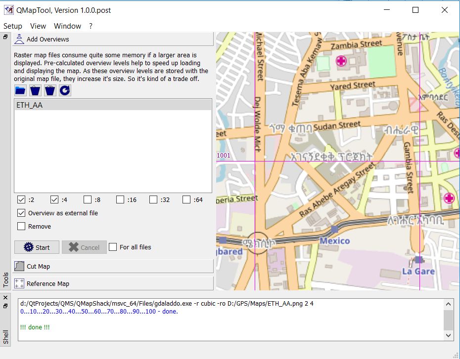
Raster map files can have a considerable size. Loading and rendering them on different zoom levels can therefore take some time. The overview tool helps to add overview maps on different zoom levels to a given map file. Overviews are reduced views of the input image for display at a lower resolution. These overviews are smaller and thus loaded and rendered much quicker than the original map. If the map with overviews is used with QMapShack, then the map is rendered on more (or even all) zoom levels (due to the heavy computational load huge maps without overviews are rendered in QMS only on reasonable zoom levels).
Overviews can be included within the map image file itself or can be built as secondary external files.
To add map overviews proceed as follows:
- Select the menu entry
Window - Shellto open the QMT shell window (docked window, can be moved on the desktop). - Click the
Add overviewsbutton in the QMTToolswindow to open the overview tool. - Click the
Open(Add map files to list) icon ( ) and select a raster map. The raster map is loaded into the QMT map window.
 - Select up to 6 zoom levels for which overviews should be created. Remark: The selected value is used as reduction factor for the original image size.
- Select the
Overview as external filecheckbox (the overview file has an additionalOVRextension added to the map filename, this file is a multipage TIFF file, its pages can be checked/rendered in an image viewer). - Click the
Startbutton to create the overview file. - The shell window (if activated) shows the used GDAL commands and the progress of the operation.

Remark: In the 3 other QMT tools (cut tool, overview tool, reference tool) a Create overviews ... option is available. This is necessary because there is no fixed order of
using these tools. When one of these tools calls GDAL for some operation, then GDAL doesn't read the overview information contained in the raster map file. Thus, overview
information should be recreated after such a GDAL operation and this is supported in each of the tools.
-
In addition to the basic steps described in the previous section some more actions with maps can be carried out in the overview tool:
Icon Tooltip 
Remove selected (map) file from the list 
Clear complete list of map files 
Reload the currently selected map -
If the
Removecheckbox is selected, then the overviews are removed from the map file. -
It is possible to open several map files. If the checkbox
For all filesat the bottom of the tool is checked, then the required action (create or remove overview) is carried out for each of the loaded map files. -
A call to the
gdalinfotool of the GDAL package (on Windows installed together with QMT) reveals if a raster map file includes overviews:gdalinfo.exe ETH_AA.png Driver: PNG/Portable Network Graphics Files: d:\GPS\Maps\ETH_AA.png d:\GPS\Maps\ETH_AA.png.ovr Size is 1920, 1080 Coordinate System is '' Image Structure Metadata: INTERLEAVE=PIXEL Corner Coordinates: Upper Left ( 0.0, 0.0) Lower Left ( 0.0, 1080.0) Upper Right ( 1920.0, 0.0) Lower Right ( 1920.0, 1080.0) Center ( 960.0, 540.0) Band 1 Block=1920x1 Type=Byte, ColorInterp=Red Overviews: 960x540, 480x270 Band 2 Block=1920x1 Type=Byte, ColorInterp=Green Overviews: 960x540, 480x270 Band 3 Block=1920x1 Type=Byte, ColorInterp=Blue Overviews: 960x540, 480x270This result shows:
- An overview file
ETH_AA.png.ovris attached to the given input fileETH_AA.png. - The original image size is 1920 x 1080.
- There are 2 overview levels with image sizes 960 x 540 and 480 x 270 (used overview levels: 2 and 4).
- An overview file
Prev (Installation and setup) | Home | Manual | Index | Top | (Cut tool) Next