-
Notifications
You must be signed in to change notification settings - Fork 65
DocHandleGpxFiles
Prev (Working with Projects) | Home | Manual | Index | (Search data) Next
Table of contents
Despite all deficiencies, GPS manufacturers support this format. A common format is a good approach in general, but TopoGrafix, the company behind GPX, fails miserably to evolve their format to the needs of today's GPS systems. Anyway, GPX is it to be. QMapShack does support the GPX definition version 1.1 and some of the proprietary extensions to GPX. And it adds a few more. But due to the sheer rank growth of extensions, caused by a lack of guidance, it can't support everything. Keep this in mind when you load and save GPX files that do not origin from QMapShack. You will loose information.
QMS is QMapShack's own binary format. You will never loose information using it, but of course it is not compatible to any other application.
There are two ways to load GPX or QMS files.
-
When you start QMapShack from the commandline you can add a list of GPX and QMS files
qmapshack file1.gpx file2.qms -
Use the menu File->Load GIS Data (GIS = Geographic Information Systems)

FIT, SLF and TCX files can be loaded in the same way.
Each file will create a new top level item in the data view's workspace list.

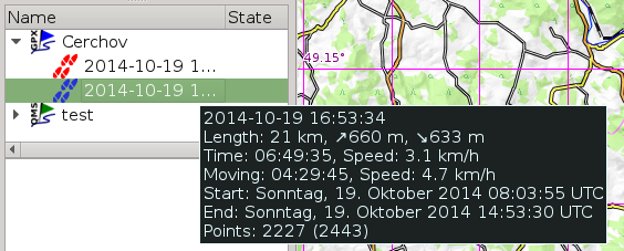
If you expand the item you can see the elements like waypoints, tracks, routes and so on. If you let the mouse hover over an element you get more information.
Mind that checking the Show on Map checkbox to the left of the GIS
item in the data view's workspace list does not move the map to
where the objects of your GIS file are located on the globe! To achieve
this expand the GIS item and then double-click on one of its tracks,
routes, or waypoints.

You can either save all files in the workspace via Save All GIS Data. Or you can save a single file by a right-click on the item in the data view's workspace list.

Prev (Working with Projects) | Home | Manual | Index | Top | (Search data) Next