Conversation
|
A few questions (disclaimer: i don't really know what ST_BUFFER does)
|
Extract and expand functions that create geometries for benchmarks.
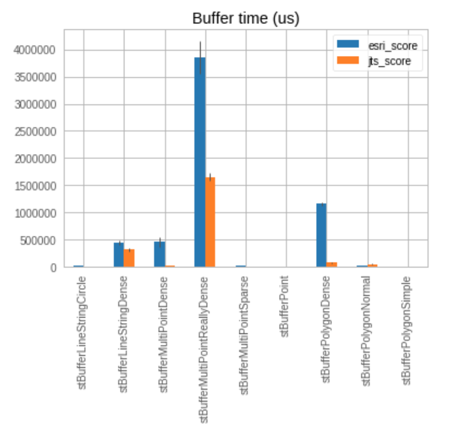
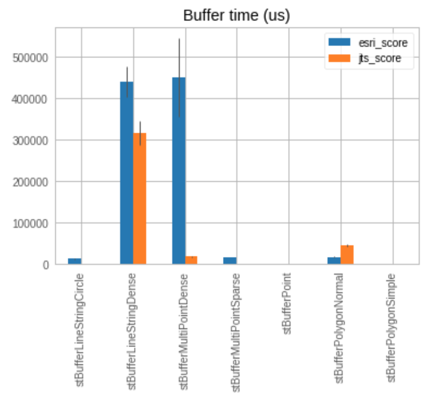
JTS is generally more efficient (see benchmarks below).  Also, ESRI
returns an empty geometry when you buffer by small distances (< 1e-9);
JTS handles these correctly.

JTS
Benchmark                                        Mode  Cnt        Score       Error  Units
BenchmarkSTBuffer.stBufferPoint                  avgt   20       14.221       2.408  us/op
BenchmarkSTBuffer.stBufferMultiPointSparse       avgt   20      810.414      43.980  us/op
BenchmarkSTBuffer.stBufferMultiPointDense        avgt   20    18539.600     998.499  us/op
BenchmarkSTBuffer.stBufferMultiPointReallyDense  avgt   20  1650058.575   71342.838  us/op
BenchmarkSTBuffer.stBufferLineStringCircle       avgt   20      562.464      26.039  us/op
BenchmarkSTBuffer.stBufferLineStringDense        avgt   20   316479.586   29001.318  us/op
BenchmarkSTBuffer.stBufferPolygonSimple          avgt   20       11.892       0.711  us/op
BenchmarkSTBuffer.stBufferPolygonNormal          avgt   20    46390.604    2958.109  us/op
BenchmarkSTBuffer.stBufferPolygonDense           avgt   20    72822.143    6841.961  us/op

Esri
Benchmark                                        Mode  Cnt        Score        Error  Units
BenchmarkSTBuffer.stBufferPoint                  avgt   20        8.290        0.541  us/op
BenchmarkSTBuffer.stBufferMultiPointSparse       avgt   20    16521.536      818.169  us/op
BenchmarkSTBuffer.stBufferMultiPointDense        avgt   20   450394.639    94490.620  us/op
BenchmarkSTBuffer.stBufferMultiPointReallyDense  avgt   20  3856960.148   300968.259  us/op
BenchmarkSTBuffer.stBufferLineStringCircle       avgt   20    13470.522     1308.101  us/op
BenchmarkSTBuffer.stBufferLineStringDense        avgt   20   440081.641    37944.614  us/op
BenchmarkSTBuffer.stBufferPolygonSimple          avgt   20       21.796        0.871  us/op
BenchmarkSTBuffer.stBufferPolygonNormal          avgt   20    16648.597     1348.367  us/op
BenchmarkSTBuffer.stBufferPolygonDense           avgt   20  1159728.778    27607.808  us/op
|
To buffer a geometry
|
|
Nice! As far as consistency, I guess my main concern would be if there were something like an inverse function where consistency between the functions would matter. Other than that seems like a good change. |
|
There's no natural inverse to buffer: the geometry is not directly recoverable. Some libraries allow buffering with a negative distance, but we forbid this. (Even if we allowed it, it's not actually an inverse operation. Consider a square with a small hole in the center: the hole would get filled in by the buffering, but would not be excavated with the negative buffering.) |
Convert ST_Buffer implementation to use JTS. JTS is generally more efficient (see benchmarks below). Also, ESRI returns an empty geometry when you buffer by small distances (< 1e-9);
JTS handles these correctly.
JTS
Benchmark Mode Cnt Score Error Units
BenchmarkSTBuffer.stBufferPoint avgt 20 14.221 2.408 us/op
BenchmarkSTBuffer.stBufferMultiPointSparse avgt 20 810.414 43.980 us/op
BenchmarkSTBuffer.stBufferMultiPointDense avgt 20 18539.600 998.499 us/op
BenchmarkSTBuffer.stBufferMultiPointReallyDense avgt 20 1650058.575 71342.838 us/op
BenchmarkSTBuffer.stBufferLineStringCircle avgt 20 562.464 26.039 us/op
BenchmarkSTBuffer.stBufferLineStringDense avgt 20 316479.586 29001.318 us/op
BenchmarkSTBuffer.stBufferPolygonSimple avgt 20 11.892 0.711 us/op
BenchmarkSTBuffer.stBufferPolygonNormal avgt 20 46390.604 2958.109 us/op
BenchmarkSTBuffer.stBufferPolygonDense avgt 20 72822.143 6841.961 us/op
Esri
Benchmark Mode Cnt Score Error Units
BenchmarkSTBuffer.stBufferPoint avgt 20 8.290 0.541 us/op
BenchmarkSTBuffer.stBufferMultiPointSparse avgt 20 16521.536 818.169 us/op
BenchmarkSTBuffer.stBufferMultiPointDense avgt 20 450394.639 94490.620 us/op
BenchmarkSTBuffer.stBufferMultiPointReallyDense avgt 20 3856960.148 300968.259 us/op
BenchmarkSTBuffer.stBufferLineStringCircle avgt 20 13470.522 1308.101 us/op
BenchmarkSTBuffer.stBufferLineStringDense avgt 20 440081.641 37944.614 us/op
BenchmarkSTBuffer.stBufferPolygonSimple avgt 20 21.796 0.871 us/op
BenchmarkSTBuffer.stBufferPolygonNormal avgt 20 16648.597 1348.367 us/op
BenchmarkSTBuffer.stBufferPolygonDense avgt 20 1159728.778 27607.808 us/op