smooth_cg_topo=T requires soil elevation data#1580
smooth_cg_topo=T requires soil elevation data#1580davegill merged 6 commits intowrf-model:release-v4.3.2from
Conversation
TYPE: bug fix

KEYWORDS: ERA5, smooth_cg_topo, elevation data

SOURCE: internal

DESCRIPTION OF CHANGES:
Problem:
If a user does not include all of the correct ERA5 invariant files, then there could be
no soil elevation field coming from the metgrid program. Without that field, the flag
`flag_soilhgt` is not set. The real program will not generate any topo differences along
the lateral boundary (when requested with smooth_cg_topo = T). This is a quite failure,
and dificult to track down.

Solution:
If the user asks to smooth the lateral boundary topo on d01, AND the user has no input
soil elevation data from the first-guess model, then this is now a fatal error.

LIST OF MODIFIED FILES:
modified:   dyn_em/module_initialize_real.F

TESTS CONDUCTED:
1. With artificial settings of the metgrid flags, we can successfully emulate missing
soil elevation data. There is a controlled stop to the real program.
2. All jenkins tests are PASS.

RELEASE NOTE: A fatal error in the real program is now issued when a user requests lateral boundary topography smoothing, but lacks the first-guess soil elevation data to do the weighted averaging of topography. Previously, this discrepancy was ignored, and the d01 high-resolution elevation data was quietly left undisturbed.
|
jenkins is OK |
|
@dudhia |
|
So for single domain runs, the elevation is blended to the incoming topo in
the boundary zone with this option?
…On Fri, Nov 5, 2021 at 4:53 PM Dave Gill ***@***.***> wrote:
@dudhia <https://github.com/dudhia>
Jimy,
This mod would have fixed Andrew's ERA5 troubles.
—
You are receiving this because you were mentioned.
Reply to this email directly, view it on GitHub
<#1580 (comment)>, or
unsubscribe
<https://github.com/notifications/unsubscribe-auth/AEIZ77E5BDAXFFUGH75F7Q3UKRU65ANCNFSM5HOZV56A>
.
Triage notifications on the go with GitHub Mobile for iOS
<https://apps.apple.com/app/apple-store/id1477376905?ct=notification-email&mt=8&pt=524675>
or Android
<https://play.google.com/store/apps/details?id=com.github.android&referrer=utm_campaign%3Dnotification-email%26utm_medium%3Demail%26utm_source%3Dgithub>.
|
|
@dudhia |
|
@kkeene44
|
|
@davegill Here is a suggestion: How about 'but found no (incoming?) terrain field from driving data in metgrid files (field name SOILHGT)'? I'm trying to use words that may 'click' with users... |
|
@kkeene44 Is there a place on our web or UG that we can add a note about invariant fields for dataset like ERA5? |
|
@weiwangncar Yes, I can add something at least in the UG. I already have an FAQ about it on the forum, and our website points to the FAQs, but not everyone looks there. |
 smileMchen
left a comment
smileMchen
left a comment
There was a problem hiding this comment.
I am OK with this PR.
|
@kkeene44 |
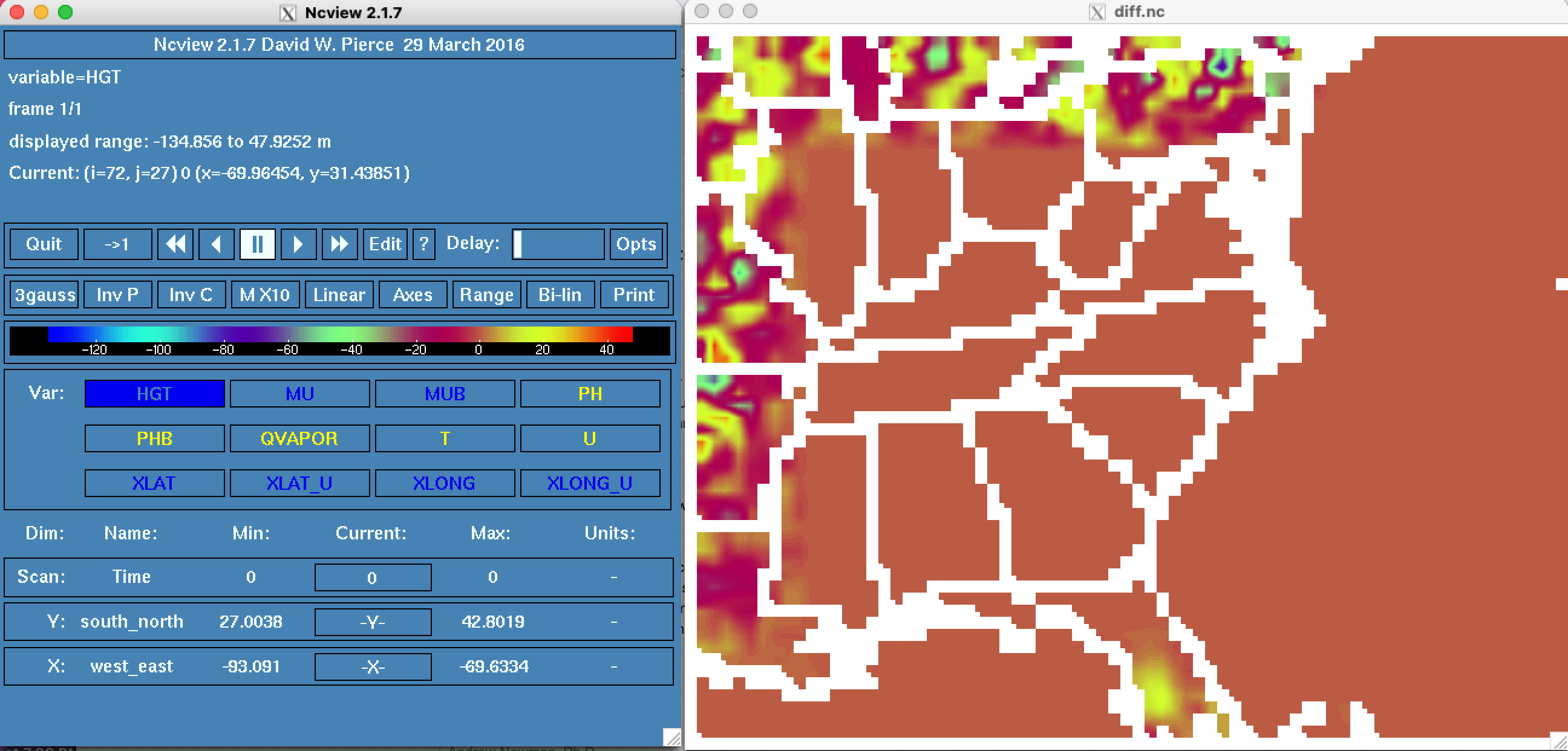
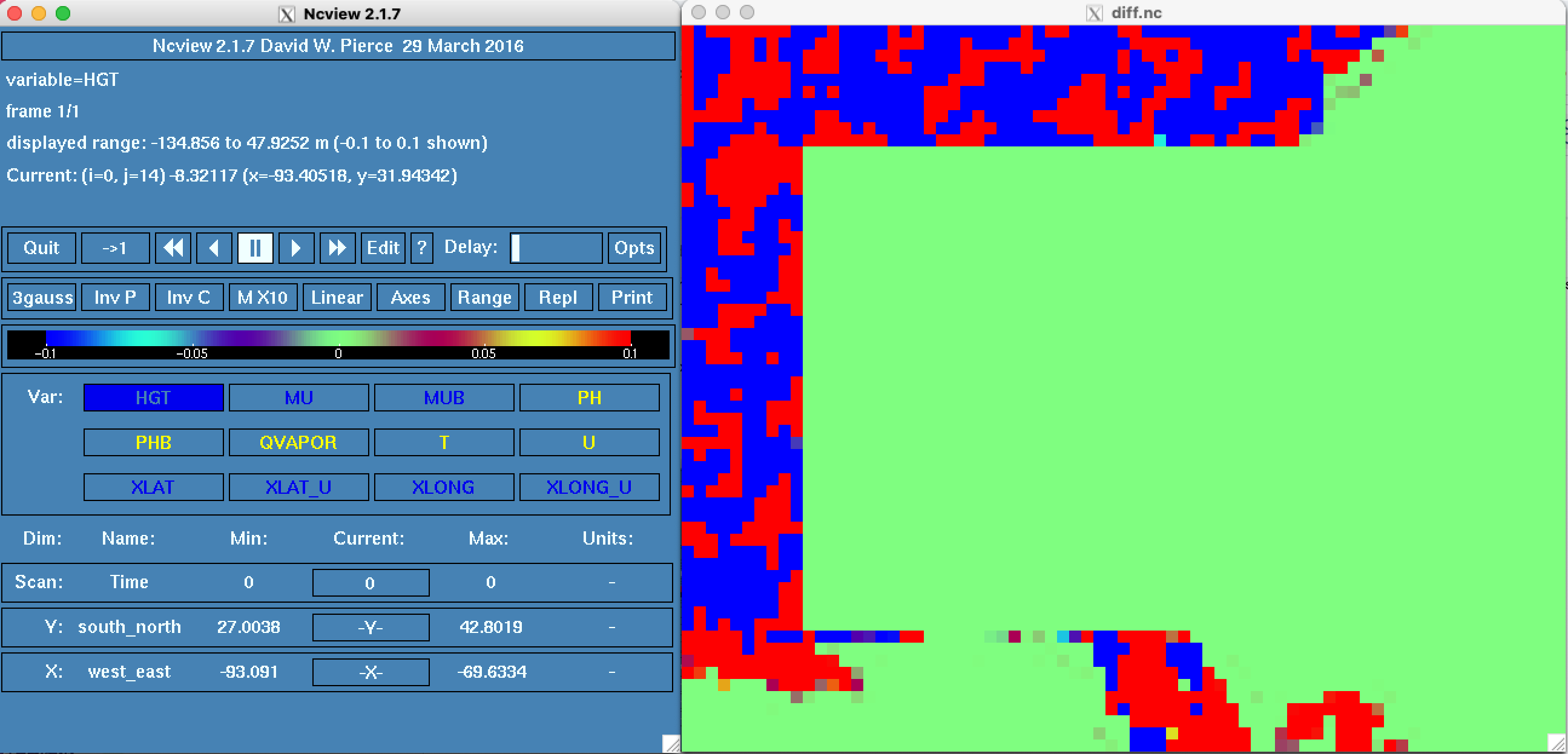
…1580)

TYPE: bug fix

KEYWORDS: ERA5, smooth_cg_topo, elevation data

SOURCE: internal

DESCRIPTION OF CHANGES:
Problem:
If a user does not include all of the correct ERA5 invariant files, then there could be
no soil elevation field coming from the metgrid program. Without that field, the flag
`flag_soilhgt` is not set. Then the real program will not generate any topo differences along
the lateral boundary (when requested with smooth_cg_topo = T). This is a quiet failure,
and difficult to track down.

Solution:
If the user asks to smooth the lateral boundary topo on d01, AND the user has no input
soil elevation data from the first-guess model, then this is now a fatal error.

LIST OF MODIFIED FILES:
modified:   dyn_em/module_initialize_real.F

TESTS CONDUCTED:
1. The original intent of the option still works - smoothed topo on d01 along the outer few rows and columns.
The first figure shows the change in topography. The second figure below shows which grid cells are
impacted. Basically, these two figures show that topography smoothing still is available.
<img width="1296" alt="Screen Shot 2021-11-05 at 11 27 03 AM" src="https://user-images.githubusercontent.com/12666234/140584624-40a71752-d718-44d3-8c3a-05f6fd710ee1.png">

<img width="1295" alt="Screen Shot 2021-11-05 at 11 45 57 AM" src="https://user-images.githubusercontent.com/12666234/140584653-f3546331-1c95-4ea3-a324-5f3a6e0cb3ee.png">

2. By artificially setting the metgrid flags in a debugging mode within the real program, we can successfully
emulate missing soil elevation data by setting flag_soilhgt = 0. Whether or not we artificially set the value,
there is now a controlled stop to the real program.
```
-------------- FATAL CALLED ---------------
FATAL CALLED FROM FILE:  <stdin>  LINE:     766
 --- ERROR: NML option smooth_cg_topo=T, but no first guess soil elevation data
-------------------------------------------
```
3. All jenkins tests are PASS.

RELEASE NOTE: A fatal error in the real program is now issued when a user requests lateral boundary topography smoothing, but lacks the first-guess soil elevation data to do the weighted averaging of topography. Previously, this discrepancy was ignored, and the d01 high-resolution elevation data was quietly left undisturbed. We have seen this problem when a user chooses to initialize the model with ERA5 data, but when insufficient time invariant files are used.
TYPE: bug fix
KEYWORDS: ERA5, smooth_cg_topo, elevation data
SOURCE: internal
DESCRIPTION OF CHANGES:
Problem:
If a user does not include all of the correct ERA5 invariant files, then there could be
no soil elevation field coming from the metgrid program. Without that field, the flag
flag_soilhgtis not set. Then the real program will not generate any topo differences alongthe lateral boundary (when requested with smooth_cg_topo = T). This is a quiet failure,
and difficult to track down.
Solution:
If the user asks to smooth the lateral boundary topo on d01, AND the user has no input
soil elevation data from the first-guess model, then this is now a fatal error.
LIST OF MODIFIED FILES:
modified: dyn_em/module_initialize_real.F
TESTS CONDUCTED:
The first figure shows the change in topography. The second figure below shows which grid cells are
impacted. Basically, these two figures show that topography smoothing still is available.
emulate missing soil elevation data by setting flag_soilhgt = 0. Whether or not we artificially set the value,
there is now a controlled stop to the real program.
RELEASE NOTE: A fatal error in the real program is now issued when a user requests lateral boundary topography smoothing, but lacks the first-guess soil elevation data to do the weighted averaging of topography. Previously, this discrepancy was ignored, and the d01 high-resolution elevation data was quietly left undisturbed.